Is Toronto Walkable? The Honest Downtown Distances
By Declan Moss
By Declan Moss · 19 August 2026
Yes. Downtown Toronto is walkable when one day stays inside one cluster. From Union Station, the CN Tower is a 10-minute walk, TIFF Bell Lightbox is 15 minutes, CF Toronto Eaton Centre is 17 minutes and Harbourfront Centre is 15 minutes on the routed-foot checks used for this guide.
The promise breaks on the diagonal. Canoe Landing Park in CityPlace to 251 Jarvis Street in the Garden District is 3.56 kilometres and 47 minutes on foot. Both addresses are downtown. They are not one walkable pocket.
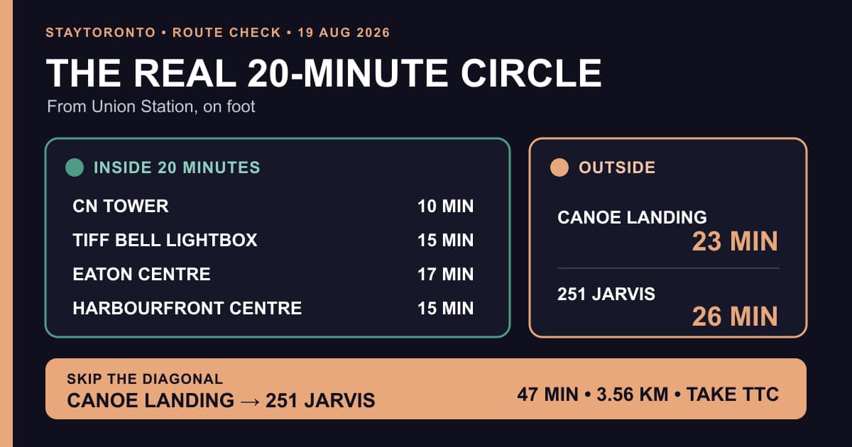
The useful 20-minute circle from Union Station. Four visitor anchors fit. Canoe Landing and 251 Jarvis sit outside it. Routed-foot estimates checked 19 August 2026.
Is Toronto walkable for a visitor?
Yes, with one rule: walk within a cluster and use the TTC between clusters.
The map most visitors see compresses South Core, the Entertainment District, CityPlace, the waterfront, the Eaton Centre and the Garden District into one rectangle. At street level, Front Street, Bremner Boulevard, King Street West and Queens Quay West make the south-west cluster easy. The long west-to-east diagonal is where the rectangle lies.
Toronto also asks for more effort than the map shows. The railway corridor narrows the useful crossings between Front Street and the waterfront. The CN Tower entrance sits south of Front. CityPlace stretches west past Spadina Avenue. The Garden District begins east of Yonge Street and continues north toward Allan Gardens.
The honest answer is not "everything downtown is walkable." It is "one downtown cluster is walkable at a time."
What is really inside 20 minutes of Union Station?
These figures start at one fixed public point inside Toronto Union Station. The destination is the mapped building or park point. The OpenStreetMap routed-foot service returned the distances and durations below. Times are rounded to the nearest whole minute.
- CN Tower: South Core to the tower entrance south of Bremner Boulevard. 10 minutes, 0.73 km.
- TIFF Bell Lightbox: Union to King Street West and John Street in the Entertainment District. 15 minutes, 1.11 km.
- CF Toronto Eaton Centre: Union to the Yonge Street shopping anchor. 17 minutes, 1.29 km.
- Harbourfront Centre: Union to 235 Queens Quay West on the waterfront. 15 minutes, 1.08 km.
- Canoe Landing Park: Union to the CityPlace park west of Spadina Avenue. 23 minutes, 1.75 km.
- 251 Jarvis Street: Union to the Garden District, east and north of the Eaton Centre. 26 minutes, 1.93 km.
That is the real 20-minute circle. It reaches the CN Tower, the centre of the Entertainment District, Harbourfront and the Eaton Centre. It does not reach the heart of CityPlace or the Garden District.
Union is a strong centre for a first visit, not because every downtown sight is beside it, but because four useful directions fit inside one walking block. The street-level South Core guide shows what that southern cluster looks like after the office towers empty.
Which shorter walks work without returning to Union?
Two cross-cluster links are shorter than they look.
- CN Tower to Canoe Landing Park: 14 minutes, 1.08 km. Moving west from the tower into CityPlace without backtracking to Union.
- CF Toronto Eaton Centre to 251 Jarvis Street: 11 minutes, 0.85 km. Moving from Yonge Street into the Garden District.
This is the better way to plan a Toronto day. Chain adjacent anchors. Do not reset to Union after every stop.
For a car-free day beyond the obvious landmarks, the hidden places guide uses the same principle: one compact walk, then transit for the gap.
Which Toronto route should you skip on foot?
Skip Canoe Landing Park to 251 Jarvis Street as one continuous walk. The routed distance is 3.56 kilometres and 47 minutes. That is the downtown diagonal, west of Spadina Avenue to the Garden District.
Use transit. From the CityPlace side, walk to the 510 Spadina corridor. The 510 Spadina runs between Spadina Station and Union Station through Spadina Avenue and Queens Quay West. From Union, ride Line 1 north to TMU Station, the station formerly called Dundas, then finish east on Dundas Street toward Jarvis.
From King Street West, the 504 King is the simple east-west move across the core. It is useful when the middle of the route is King, not when the destination is the Eaton Centre itself.
The portable rule: if the walk crosses both Yonge Street and Spadina Avenue, open the TTC route planner before committing to the pavement.
Who should not plan to walk downtown all day?
Do not build the day around walking if you use a mobility aid, have limited walking stamina, are moving with a stroller, or are hauling luggage. The same goes for freezing rain, unshovelled corners and humid heat. A ten-minute map estimate does not remove curb cuts, construction hoarding, station corridors or a wait at the lights.
Union and TMU Station are accessible Line 1 stations. The TTC publishes its elevator locations and live accessibility guidance. Build that information into the route before reaching the platform.
The PATH solves a different problem. It is useful for weather-protected movement around Union and the Financial District during the workday. It is not a dependable all-hours shortcut across downtown because individual links follow the hours of the properties they pass through. Read the honest PATH guide before turning the underground network into a winter plan.
Which downtown base matches the walking plan?
Pick the base nearest the cluster that matters most. None of the four StayToronto locations wins every route.
- York in South Core fits Union, the CN Tower, the waterfront and the Financial District.
- Atmos in the Entertainment District fits King Street West, TIFF Bell Lightbox, the CN Tower and Rogers Centre.
- Parade in CityPlace fits Canoe Landing, Fort York and the western waterfront.
- Jarvis in the Garden District fits the Eaton Centre, Dundas Street, Toronto Metropolitan University and Allan Gardens.

Four real first-party StayToronto photos, one from each stay area. Clockwise from top left: Atmos, Parade, Jarvis and York. They show specific units or views, not every layout or view.
This is why "central" is a weak booking filter. A base at the centre of the map still leaves a long diagonal if the daily plan sits at one edge. Match the address to the first and last stop of most days.
Before you go
- Routing results can change when construction closes a sidewalk or entrance. Re-run the longest walk for the travel date.
- TTC routes can divert for track work, road closures and events. Check the live route page before leaving.
- Elevator availability can change during the day. Check the TTC accessibility alert before a step-free trip.
- Ice, snow, heat, crowds and luggage can add time. Treat the table as fixed-point planning estimates, not door-to-door promises.
- PATH doors can follow individual building hours. Keep the surface route saved.
Sources
- OpenStreetMap routed-foot service for every distance and walking duration in the tables.
- TTC 510 Spadina and TTC 504 King.
- TTC Union Station, TTC TMU Station and TTC elevators and escalators.
StayToronto is not affiliated with the TTC, OpenStreetMap, the attractions or the venues named in this guide.
About this guide
Written by Declan Moss. Walking routes were checked with the OpenStreetMap routed-foot service, and transit facts with current TTC pages, on 19 August 2026.
Compare short-term furnished stays across downtown Toronto. Choose the address nearest the cluster you will use most, then let the TTC handle the diagonal.
Frequently asked questions
Is Toronto walkable for tourists?
Downtown Toronto is walkable for tourists who group sights into one cluster. Union Station to the CN Tower, TIFF Bell Lightbox, the Eaton Centre and Harbourfront Centre all fit inside 17 routed minutes. CityPlace to the Garden District does not.
How long is the walk from Union Station to the CN Tower?
The routed-foot result is 10 minutes and 0.73 kilometres from the fixed Union Station point to the mapped CN Tower point.
Can you walk from Union Station to the Eaton Centre?
Yes. The routed-foot result is 17 minutes and 1.29 kilometres. Line 1 to TMU Station is the stronger choice with luggage or limited walking stamina.
When should you use transit instead of walking in downtown Toronto?
Use transit when the route crosses two clusters. Canoe Landing Park to 251 Jarvis Street is the clearest example at 47 minutes and 3.56 kilometres on foot. The 510 Spadina corridor and Line 1 break up that diagonal.
Is the PATH a substitute for walking outside?
Only inside the office-core cluster and only when the required links are open. PATH is not a continuous, all-hours route across CityPlace, the Entertainment District and the Garden District.